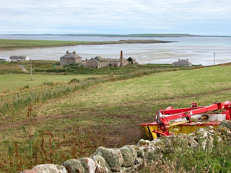
 South End of Sanday: Looking Over Stove, with Stronsay in the Distance |
Sanday is the largest of the north isles of Orkney and the most north easterly of the larger islands: lying north of Stronsay and south of North Ronaldsay. The author Eric Linklater described its shape as like a fossilised, gigantic bat. Seeing this takes some imagination: you can also think of it as a fairly narrow and irregular island extending some 15 miles from south west to north east, with a peninsula stretching north from its centre.
| ||||||||
Sanday is very low lying, rising to a maximum height of 65m near its south west end at The Wart, not far from Loth and its ferry terminal. The name of the island comes from the broad sandy beaches that fringe many of its long bays. The north and east of Sanday are especially low lying, making this the last resting place of many ships whose crews simply didn't see the island at night or in fog before running into it.
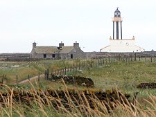 Start Point Lighthouse | |
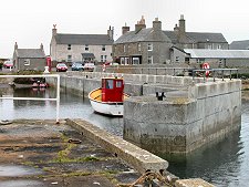 Kettletoft | |
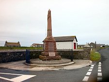 War Memorial at Lady Village | |
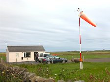 Sanday Airfield | |
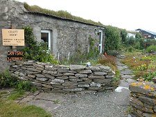 Orkney Angora Craft Shop |
On an island without peat, the supply of wood that these wrecks provided kept generations of islanders warm: it has even been said that prayers were said in church to seek the Lord's assistance in ensuring that this supply of fuel didn't dry up. The construction of the Start Point lighthouse at the island's west end in 1806 helped mariners considerably, but it was only in the era of radar that Sanday became visible enough to be more consistently avoided.
The main settlements on Sanday are at Lady Village, approximately in the centre of the island, and Kettletoft, on a small peninsula projecting south from the island. The island's population shrank from over 2000 in 1881 to 533 in 1991: and still further to 478 in 2001. The signs of this depopulation are visible throughout the island, and in some parts it seems that for every inhabited croft, cottage or farm there is at least one more abandoned and in ruins. There are also two ruined churches on the island: Cross Kirk, near Kettletoft, and Lady Kirk, near Lady. The latter comes complete withThe Devil's Clawmarks, a rather spooky set of grooves in the balustrade at the top of a set of steps.
If the evidence of recent habitation is strong throughout Sanday, so is the evidence of its ancient residents, stretching back thousands of years. Sanday has been referred to as the connoisseur's island for archaeology, and wherever you look, there seem to be humps and bumps that date back beyond recorded history.
In part the preservation of the archaeology is down to the style of farming here over the centuries; and in part it is due to the fact that much of Sanday is physically growing rather than eroding. But it is also due to the respect of islanders for the hogboons. Islanders believed that each burial mound was home to a hogboon, an ill-willed and bad-tempered creature which went out of its way to cause trouble for any human who disturbed it.
Sanday's best known ancient monument is the Quoyness Cairn, on a promontory on the opposite side of Kettletoft Bay from Kettletoft. But it is indicative of the importance of the area that the promontory is also home to a further 27 cairns. In the far north east of the island, excavations at Tofts Ness have revealed what is probably one of the richest archeological areas in Britain, with over 500 burial mounds plus settlement mounds and other features.
Meanwhile, near Scar, at the tip of the northern peninsula, a Viking boat burial was exposed during a storm in 1985. Subsequent work unearthed a beautiful whalebone plaque now on view at the Orkney Museum in Kirkwall: plus the skeletons of a man, woman and child; a sword; a quiver containing eight arrows; a comb; and 22 gaming pieces.
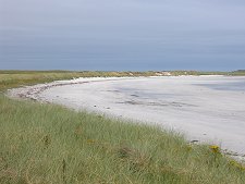
Sanday is also famed for its wildlife. Common and grey seals (or "selkies") are habitual residents and can often be seen in many places around the island. Otters are also resident, though much more elusive. Seabirds abound, and the beaches are famed not just for their sand, but also for their sea shells, many difficult to find elsewhere.
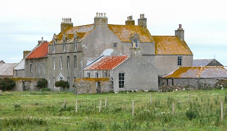 Scar House |
Kettletoft is one of Sanday's two significant settlements, the other being Lady Village, nearer the centre of the island. It is located on the south side of Sanday, looking east across Kettletoft Bay to the near island of Els Ness, home to the Quoyness Chambered Tomb and many other ancient mounds.
| ||||||
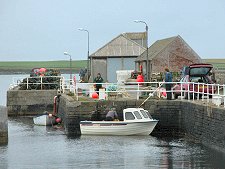
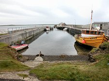
Kettletoft grew around its fishing industry, though it never became as significant a port as Whitehallon Stronsay, which lays five miles due south of it across the Sanday Sound. During the herring boom of the late 1800s and early 1900s Kettletoft was a hive of activity with boats landing their herring; herring girls gutting and salting the catch; and vessels carrying the processed product off to distant markets.
 Kettletoft Pier | |
 Harbour from the Village | |
 Fish Boxes on Harbour |
The village was also important as the main point of entry to, and exit from, Sanday. The steamers that established the routes to the north isles, including Kettletoft, in the 1800s and early 1900s were replaced by the MV Orcadia from 1961 to 1990.
She in turn was replaced by the new generation of car ferries which operated from a roll-on roll-off pier at Loth near Sour Ness at the southern tip of Sanday in the early 1990s: and Kettletoft's harbour became a less busy place overnight.
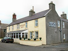
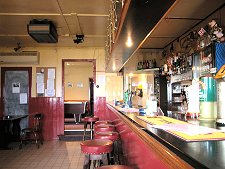
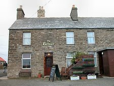
Many of the buildings in Kettletoft have their backs to the sea, in a sort of rural version of Stromness or Lerwick. These include the island's two hotels, the Belsair and the Kettletoft Hotel.
The Belsair Hotel stands at the head of Kettletoft's old pier. Built in what was originally a house and an adjoining post office, some of its ensuite rooms offer sea views; while for those on the island for the day, it offers lunches and dinners. The Kettletoft Hotel also offers a choice of recently refurbished accommodation plus lunches and evening meals. The views of the harbour are extremely good and offer a particularly pleasant diversion as you relax over a drink or an excellent lunch here.
Just to the west of Kettletoft is one of Sanday's best beaches, Backaskaill Bay. This can be approached from the road from Loth and the ferry: or via a side road just north of Kettletoft itself. This takes you to the bay via the ruins of Cross Kirk, a rectangular church built in about 1700. Only the gables and south wall now survive above ground level. It is thought that the kirk was built on the site of an earlier Viking settlement.
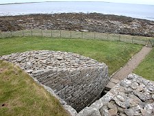
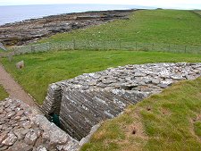
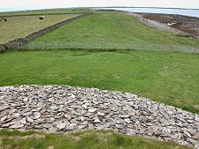
Quoyness Chambered Tomb or Cairn is one of the most impressive ancient monuments on Orkney. It lies near the east shore of Els Ness, an isolated promontory of land almost separated from the rest of Sanday. Els Ness is also home to a further 27 cairns of various sorts, suggesting this was a particularly important area for our Bronze Age ancestors who built the tomb some 5000 years ago.
| ||||
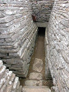
You reach Quoyness Cairn via a rough track (passable by car) that starts near the ruins of Lady Kirk;east of Kettletoft and south west of Lady Village. From the obvious parking area it is about a 20 minute walk along a grassy track beside the shore to the cairn itself.
Quoyness was built on an irregular stony platform some 20m across close to the shore of Els Ness. The platform was built as a sandwich of flat slabs containing a filling of stone, earth and midden.
 Looking South from the Cairn | |
 North Along the Approach Path | |
 Inside a Side Chamber |
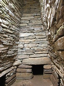
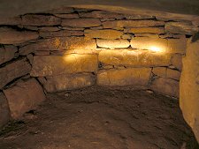
At the heart of the cairn is a beautifully constructed rectangular dry stone chamber 4m in length, 2m in breadth and an impressive 4m in height. This is now capped by a windowed cover to let in light: it was probably originally covered by a dome of earth.
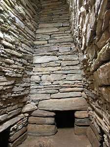
The central chamber gives access to six side chambers in a way very reminiscent of Maes Howe. When the cairn was fairly roughly excavated in the 1800s it was found to contain the bones of at least 10 adults and 5 children; pottery; and bone and stone artefacts.
Those doing the digging were more interested in emptying the structure than in finding out about the details of 3000BC life, so a lot of information was probably lost during the process.
The central chamber is contained within a small inner cairn, which in turn is contained within a much larger outer cairn. The entrance tunnel originally ran for 9m through both layers of the cairn.
The reconstructed entrance leaves the outer 5.5m as a deepening stone lined trench, and unroofed, leaving visitors to revert to their hands and knees for a muddy crawl only for the inner 3.5m. Crawling through the full 9m of the original tunnel would not have been recommended for claustrophobics!
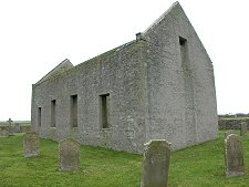
The austere ruins of Lady Kirk lie perhaps a mile south west of Lady Village and a mile north east of Kettletoft.
| ||||
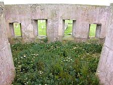
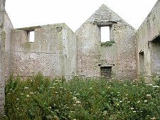
The church, whose walls still stand to their full height, dates back to 1773 but may well include walls from an earlier church. A door at the west end, obscured by a porch added in 1902, has been identified dating back to the 1600s.
The fact that until its redundancy the church's effects included a pre-reformation communion cup suggests that there could well have been a series of churches or chapels on this site, perhaps dating back to to the Viking era or beyond. No physical evidence of this has been found, so it has to remain as speculation.
 Seen from the South East | |
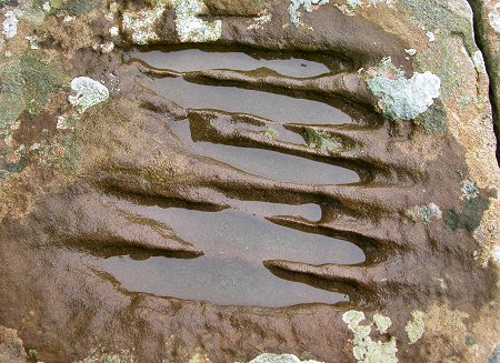
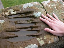 The Devil's Clawmarks |
Today the exterior of the church is a study in grey, while the roofless interior doubles as an informal nature reserve. But most people come to Lady Kirk to look at one feature in particular.
At the top of the steps that once gave access to the north gallery, the dressed stone balustrade carries a series of deep grooves known as the Devil's Clawmarks.
These are rather spooky, despite the fact that it would take a fairly large being with at least six fingers or claws to have made the marks in question. On the whole the sceptic is more likely to conclude that these are what is left of some sort of erosion of the stone from which the balustrade was cut.
But why would skilled masons have chosen to dress and expose the eroded side of a stone when all they'd have needed for a perfect finish would have been to work it the other way up: or use another piece of stone?
 |
.undiscoveredscotland
No comments:
Post a Comment